Itinerary
This part of the route offers a perfect mixture of history and nature. The path is rather flat and it goes across olive trees fields, through pine woods, and afterward it stretches from the bottom of Turón Castle to the Town of El Burgo, home of a beautiful track along the river.
Summary
Stage 22 begins and ends on the Turón river, as it flows through the towns of Ardales and El Burgo. In the absence of a more direct route along the valley that runs between these points, the Stage resorts to climbing up to over 800 metres. In doing so, it passes through the three publicly-managed and forested hills on the marly limestone of the Sierra de Ortegķcar. The route’s profile therefore, shows a significant rise and fall over what is, a relatively demanding distance.
To approximately the halfway point, it heads west and then south at Los Mįrquez. The forestry and country tracks it runs along are in good condition throughout. This is thanks, in the middle section, to maintenance of the Montes Pśblicos (Public Uplands Forest), whereas in the initial and final sections, they are access roads to several well-known country estates and farmland. Almost half of the route is under the shade of Aleppo pine forests growing on these clay ridges. In terms of the municipal areas, it pushes on through Ardales up to kilometre 8.2. Then, for just over 2.5 km it runs along the border between this and El Burgo and finally, from Los Mįrquez onwards, through the land belonging to the end of the stage.
The route travels through to a fairly unknown mountainous area located in the triangle of Ardales, El Burgo and Serrato. It is wedged between the Ortegķcar mountain range and the Guadalteba river to the north and the Turón river to the south. The area is very popular with hikers and mountain bikers, with its famous Espinazo del Perro circular route and a network of forest tracks that allow a wide variety of circular routes. This also includes the fifth section of the GR7 E4 route along with two other Short Routes (PR in Spanish– Pequeńo Recorrido).
This stage of the GR-249 covers extensive and dense areas reforested with Pine trees on marly limestone, on which Holm oaks, Junipers and Savin junipers also begin to flourish. The woodland around the River Turón deserves special mention, for its exemplary conservation at times.
The best
This Stage takes the hiker to a sierra which is quite unknown, located limestone Sierra de Ortegicar to the north, and the Rķo Turón to the south. The area is quite popular with walkers and mountain bikers, with the famous circular route called Espinazo de Perro and a network of forest trails that allow planning diverse circulars including the GR-7 E-4 in his fi fth leg.
It is the first time that the GR-249 follows such a huge area of marly limestone covered with a repopulated forest, rather dense in some spots with Oaks, junipers and savins.
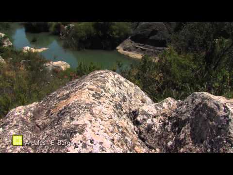
The departure and arrival, in turn, let you meet the Rķo Turón, just before the dam of the Conde Guadalhorce, which can be seen from various points, as in two previous stages.