Itinerary
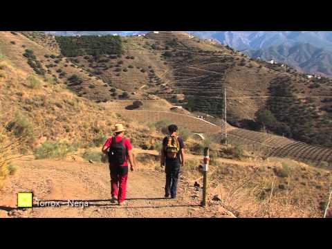
Along the curvy way that goes across the Port of Torrox, you will go across many tropical farms until you see the source of the Chillar River in Nerja, which is the end of this stage.
Summary
Stage 4 runs between the two easternmost municipalities on the Province’s coast, Torrox Costa & Nerja. Both are located close to important rivers originating in the mountains of Sierra Almijara. Firstly, the Torrox which vaguely follows a line from Cerro Lucero (Stage 6) and the Chķllar, which is crossed again on Stage 5, has its source on the eastern slopes of Navachica. The change of municipality takes place at a small stream known as Los Frontiles.
The general direction is east, following the coastline and thus running parallel with the N-340 motorway. During the initial and final sections, you walk on the beach or along the rocky coastline. There is one longer section alongside the motorway, and separated from the coast by the odd house or field, which at times only leaves a narrow passage to walk along. With the addition of the pathways along the clifftops in the middle section of the stage, the assortment of trail types used throughout, is completed.
The lower courses of both rivers are really the only transitable routes to travel inland from La Axarquķa coast, owing to the surrounding peaks formed of slate. These would normally not be as imposing however, in the Stage’s middle section they drop directly into the sea from 150 metres, with a small platform cut into the rock for the motorway,just 25 metres above the sea. It is difficult not to be impressed by the fact that, even in such a hostile environment, traces of the vineyards that disappeared at the end of the 19th century, can still be seen in the dry-stone walls. The same mountain sides and equally unexpected places, are now sprinkled with the dwellings of residential developments and tourist amenities.
The best
El Puente de las Animas is a good example of a traditional road bridge which was placed in the best possible location considering the terrain and the destination of the road. It was built using local materials and has been very important to the village, even though its old charm pales compared to the brand-new, imposing road bridge which rises merely a few metres away.
Slate slopes surrounding Torrox in the east seem to be reclaiming their mountain status here, because of their altitude and their steepness. This feel is added to by Torrox river, a deep gash in the abrupt terrain. Subsistent agriculture, extensive animal husbandry and other types of exploitation have caused deforestation of the landscape throughout the centuries, though from time to time you can find a surviving example of the primeval cork and holm oak forests which used to thrive here. There is a shaded area between km 1.5 and 3 where the existence of such forests in the past is particularly evident. There is also a diversity of shrubs and fauna associated with them, especially birds.
The GR lets you visit for the first time along the walk, in a long section, the different types of cultivated subtropical tree plantations, from the extensive areas of irrigated land on the southern slope of the Cerro Pastor to the small terraced orchards where you find the ever-present varieties of avocados mixed with kiwi, custard apple, mango, papaya and loquat. This is a new industry which is taking over, as there is more water made available to irrigate the land compared to the times when only dry crops were grown. The old crops are still present; above there are long dry stone walls surrounding rows of olive trees, some almond trees and a few surviving grapevines. The entire Axarquķa coast has witnessed this modifi cation of its landscape at the beginning of the new millennium with the exuberant greenness of foreign trees. These trees require high temperatures which are typical of Axarquķa but they also require irrigation which involves intelligent management of water resources.
Ultimately, the walk takes you along the fi nal sections of the major rivers: Rķo Torrox and Chillar which flow directly into the Mediterranean Sea in the south, which may encourage you to get to know each one of their tributaries in the future Stages of the Gran Senda de Mįlaga. The mountain ranges Las Sierras Tejeda y Almijara, though seemingly far away, supply the very necessary water for human consumption and for the industry, mainly agriculture, using drainage channels running along forested mountain slopes.