Itinerary
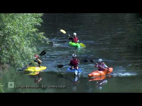
This beautiful route goes between holm and gall oaks, poplars and ash trees, follows the railway that stretches from Bobadilla to Algeciras and goes along the River Guadiaro, where you can admire people who go kayaking in its pure waters.
Summary
Stage 25 runs along with the south-eastern boundary of the Sierra de Grazalema Natural Park, on the Cańada Real (an ancient livestock track protected by Royal Decree). The valley of the River Guadiaro follows a long and straight line, below limestone mountains. These tower 1,000 metres above the river, and rise to a height of 1,400 metres above sea level. The route passes over land belonging to Benaojįn and Jimera de Lķbar in almost equal proportions, while the Seco stream marking the approximate halfway point.
Heading south-west almost throughout, the path climbs above the running water below, to then drop down on several occasions. These undulations coincide with the main tributaries arriving from the left, the Agua, Fuente Enrique and Seco streams. In its central part, the route is fairly narrow and requires extra care and attention while walking along it. The rest is along a wide track or concrete and surfaced roads towards the end. The train can also be used to return to the starting point.
The route makes use of traditionally wider trails, and specifically the Cańada Real of the region of Campo de Gibraltar, from which it separates at the railway station. This has for centuries been one of the principal transit routes between the Campo de Gibraltar and the Ronda plateau. However, the proximity to the River Guadiaro and its flooding, made various expensive means of crossing necessary, such as small boats and rustic bridges. For this reason, the so-called Camino Inglés (the English Way) running along the watershed between this valley and the Genal, was the preferred route to reach Ronda from the south.
This area has been the scene of various military confrontations from Roman times to the end of the 19th century. The ruggedness of the landscape, its steep slopes, the Holm oak and Gall oak forests and a network of reasonably-sized tributaries, have also served as a refuge for bandits and fugitives. The turning point was the construction of the Algeciras-Bobadilla railway line from 1892 onwards. It utilises numerous tunnels and viaducts to cut through the valley’s complex relief. The pathway also allows you to appreciate a well-maintained river with its gallery forest and a healthy population of easily visible fish, among which, the Andalusian barbels stand out most.
The best
At least two different settlements have grown around the train stops; there are many orchards and irrigated farmed land with trees, mainly in the right bank and with irrigation ditches coming from the tributaries and not the river itself. In Benaojįn this would be the Cascajales river and in Jimera the Artezuelas. The horticultural and fruit varieties of each place are significant, Jimera growing those requiring a much milder climate and little frost. In fact, the mild climate of Jimera Station should be considered an incentive for walkers; it is small wonder there used to be a spa in the area.
At the beginning of the stage there were numerous mills, eleven in total. Some of them are at the foot of the path, and others are equally distributed on both sides, sometimes between orchards. The star feature of the day is Guadiaro Valley, which runs through the area known as Las Angosturas (narrow gullies) with the characterised V shape. The landscape consists of gray ridges reaching over 1,000 meters, Holm and Portuguese gall oak woods on the sides and a sizeable belt of riparian wood makes one want to look around at every possible vantage point which there are many of along the path. Another attraction is the plentiful tributaries on either side of the river; some of them carry water year round.
Permanent human presence in las Angosturas, the southern boundary of the Sierra de Grazalema Natural Park, could be described as non-existent. Only if you pay close attention you will fi nd farmsteads immersed in the forest, and the only feasible access is to the ruins of the Venta del Arroyo del Agua, with its threshing circle and paved front yard.